Weathering It: How to Read Marine Forecasts Like a Professional Mariner
Every Skipper's Most Vital Skill Begins Before the Lines Are Cast Off
There is an old mariner's maxim that the sea does not care how experienced you are — only how prepared. No matter how well your vessel is fitted out, from keel to masthead, the single greatest variable standing between a safe passage and a dangerous one is the weather. Understanding how to read, interpret, and act on marine forecasts is not merely a seamanship skill; it is a survival discipline. A weather-literate skipper commanding a well-maintained boat is, without question, the safest vessel afloat.
This article is your comprehensive guide to reading marine forecasts like a professional mariner. We cover GRIB files, synoptic charts, the Beaufort Scale, sea state terminology, the critical differences between inshore, offshore, and ocean forecasting, and the best digital tools available today for real-time weather monitoring at sea.
Understanding the Language of the Sky and Sea
Synoptic Charts: The Big Picture
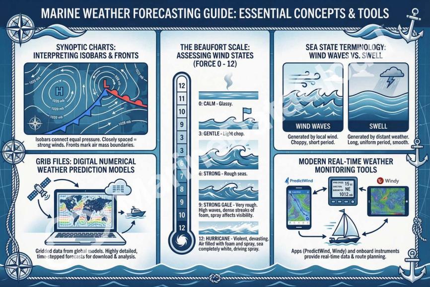
Before diving into digital tools, every competent sailor must first understand the synoptic chart — the traditional backbone of meteorological interpretation. A synoptic chart maps atmospheric pressure across a wide geographic area at a specific moment in time, displaying isobars (lines of equal pressure), frontal systems, high- and low-pressure centres, and the general airflow pattern.
Reading isobar spacing is fundamental: tightly packed isobars indicate steep pressure gradients and strong winds, whilst widely spaced isobars suggest lighter, more settled conditions. Cold fronts are depicted as blue lines with triangular barbs; warm fronts as red lines with semicircles. An occluded front — where a cold front overtakes a warm one — is shown in purple and typically signals the most complex and unsettled weather.
For passage planning, synoptic charts provide the strategic view. They help you anticipate what is coming over the next 24 to 72 hours, identify developing low-pressure systems, and understand the broader meteorological context before you ever leave the pontoon.
GRIB Files: The Navigator's Digital Weather Engine
Once the domain of professional meteorologists and ocean racers, GRIB (Gridded Binary) files are now accessible to any sailor with a smartphone or chartplotter. A GRIB file is a compressed, gridded data format that packages numerical weather prediction (NWP) model outputs — wind speed and direction, wave height, precipitation, and barometric pressure — into downloadable datasets that can be overlaid on digital charts.
Tools such as Windy, PredictWind, OpenCPN, and Passage Weather render GRIB data in intuitive, visual formats that allow skippers to interrogate forecasts at specific waypoints and time intervals. PredictWind, in particular, cross-references multiple weather models — including GFS, ECMWF, and its own proprietary high-resolution models — giving offshore sailors a layered, comparative view of forecast confidence.
Critically, a GRIB file is not a forecast in itself. It is raw model output. The ability to interpret what that data means for your specific route, sea area, and vessel type is what separates a truly prepared skipper from one who merely glances at a weather app. Model divergence — when two models show significantly different outcomes — is itself a valuable signal: it indicates forecast uncertainty and warrants caution.
The Beaufort Scale: A Timeless Instrument of Sea Wisdom
Devised by British Admiral Sir Francis Beaufort in 1805, the Beaufort Scale remains one of the most elegant and universally applicable tools in the mariner's arsenal. It relates observed sea and wind conditions to a numerical scale running from Force 0 (flat calm, zero knots) to Force 12 (hurricane-force, over 64 knots).
Understanding the Beaufort Scale in practical terms is essential for any skipper:
- Force 0–1: Calm to light air. Mirror-like sea. Ideal for dinghy sailing and motoring.
- Force 2–3: Light to gentle breeze. Small wavelets. Comfortable conditions for most boats.
- Force 4: Moderate breeze, 11–16 knots. White horses begin to appear. Good sailing.
- Force 5–6: Fresh to strong breeze. Moderate waves with spray. Reefing territory for smaller vessels.
- Force 7: Near gale. Sea heaps up. Foam begins to streak the surface. All but the most experienced should seek shelter.
- Force 8–9: Gale to severe gale. High waves, reduced visibility. Demanding conditions even for seasoned offshore sailors.
- Force 10–12: Storm to hurricane. Catastrophic sea states. No recreational vessel should be at sea.
The Beaufort Scale's genius lies in its observational nature — you can assess conditions visually and without instruments, a skill of immeasurable value when electronics fail.
Sea State Terminology: Speaking the Mariner's Language
Alongside wind speed, professional mariners describe the sea state using the World Meteorological Organisation (WMO) Sea State Scale, which classifies wave height from Code 0 (calm, glassy, 0 metres) to Code 9 (phenomenal, over 14 metres). Significant wave height (SWH) — the average of the highest one-third of waves — is the standard metric used in marine forecasts.
Understanding the difference between wind waves (locally generated, steep, and short-period) and swell (longer-period waves generated by distant weather systems) is vital. A crossing swell combined with steep local chop can create confused sea states far more dangerous than either condition alone. When a forecast states "moderate swell from the south-west with wind waves," read that as a potentially uncomfortable beam sea if your heading runs east to west.
Inshore, Offshore, and Ocean: Three Very Different Forecasting Worlds
One of the most critical distinctions for any mariner is understanding that "marine weather" is not a single category. The type of forecast you need depends entirely on where you are sailing.
Inshore Forecasting
Inshore forecasts, typically covering waters within 12 nautical miles of the coast, are issued by national meteorological agencies — the UK Met Office, NOAA in the United States, Météo-France, and others. In the UK, the iconic Shipping Forecast — broadcast on BBC Radio 4 at set times daily — has guided mariners around British coastal waters since 1867. Inshore forecasts account for local topographic effects: sea breezes, katabatic winds, tidal races, and coastal funnel effects that model data often misses.
Offshore Forecasting
Offshore forecasting covers passages beyond the inshore zone, typically out to 200 nautical miles. At this range, synoptic-scale systems dominate, and GRIB data becomes increasingly important. Skippers planning offshore passages should cross-reference at least two independent models and examine the forecast progression over 72–96-hour windows. The ECMWF (European Centre for Medium-Range Weather Forecasts) model is widely regarded as the most accurate global model for medium-range forecasting.
Ocean Forecasting
For ocean passages — Atlantic crossings, Pacific circuits, or any blue-water voyage — the forecasting discipline shifts fundamentally. Synoptic-scale planning using GRIB files must be supplemented with routing software, climatological pilot charts, and awareness of large-scale patterns such as the Intertropical Convergence Zone (ITCZ), trade wind belts, and the positions of seasonal high-pressure systems. PredictWind's offshore weather routing tools are specifically designed for this scale of passage planning.
The Best Apps and Instruments for Real-Time Weather Monitoring at Sea
A professional mariner never relies on a single source. A layered approach to weather intelligence is the standard:
- PredictWind : Multi-model GRIB data, offshore routing, and a dedicated satellite communications package for blue-water sailors. Trusted by America's Cup teams and ocean racers alike.
- Windy : Highly visual, free-to-use platform with multiple model overlays. Excellent for coastal and offshore planning.
- Passage Weather : Clean, accessible 7-day wind and wave forecasts tailored specifically to sailors.
- Navionics Boating : Integrates weather overlays with chart navigation, making it the go-to app for coastal cruisers.
- Savvy Navvy : Often described as "Google Maps for boats," it integrates tides, weather, and routing intelligence in one platform.
On board, instruments are equally important. A reliable barometer remains indispensable — a rapid pressure drop of more than 8 hPa in three hours signals an approaching storm. Wind instruments (masthead unit feeding a digital display) give real-time apparent and true wind data. An AIS receiver helps you monitor vessel traffic in reduced visibility. For offshore passages, a dedicated SSB radio or satellite communicator provides access to weather fax (WEFAX) broadcasts and GRIB data even when mobile networks are out of range.
Summary: Key Takeaways for the Weather-Literate Skipper
- Synoptic charts give you the strategic, big-picture view of developing weather systems. Learn to read isobars, fronts, and pressure centres.
- GRIB files are powerful model-output tools, not finished forecasts. Use them comparatively and with professional scepticism — model divergence signals uncertainty.
- The Beaufort Scale is a timeless, observational framework that every mariner should know instinctively, from Force 0 to Force 12.
- Sea state terminology — significant wave height, swell vs. wind wave, WMO codes — allows you to interpret forecast language accurately and anticipate on-board conditions.
- Inshore, offshore, and ocean forecasting are three distinct disciplines requiring different sources, tools, and levels of meteorological literacy.
- Digital tools such as PredictWind, Windy, and Passage Weather, combined with on-board instruments including barometers, wind instruments, and satellite communicators, provide the layered weather intelligence that professional mariners depend upon.
- Above all, the safest vessel afloat is not the largest or the most expensive — it is the one commanded by a well-prepared, weather-literate skipper.
The weather will always be the final arbiter of any voyage. Respect it, study it, and you will navigate with confidence toward every horizon.