Onboard Electronics: Building Your Perfect Navigation Suite
Onboard Electronics: Building Your Perfect Navigation Suite
From chartplotters and AIS transponders to NMEA 2000 networks and EPIRB beacons — master your digital cockpit and make electronic competence a cornerstone of modern seamanship.
Charting the Course: Why Your Nav Suite Matters More Than Ever
There was a time when a compass, a paper chart, and a keen eye on the horizon were all a mariner needed. Those days, whilst romantically appealing, are firmly astern. Today's waterways — from the busy shipping lanes of the English Channel to the remote anchorages of the Pacific — demand a navigator who is equally comfortable at the helm and at the helm of their electronics suite. Digital competence is no longer an optional extra for the weekend sailor; it is a core seamanship skill, as fundamental as reading the weather or trimming a sail.
The modern nav station is a carefully orchestrated ecosystem of interconnected instruments, each contributing its data stream to the greater picture of situational awareness. Building that ecosystem correctly — selecting the right devices, networking them intelligently, and engineering meaningful redundancy — is what separates a genuinely capable vessel from one that merely looks the part at the marina. This guide walks you through the full hierarchy of marine electronics, from the chartplotter at the heart of your system to the EPIRB beacon you hope you'll never need.
The Command Centre: Chartplotters and Multifunction Displays
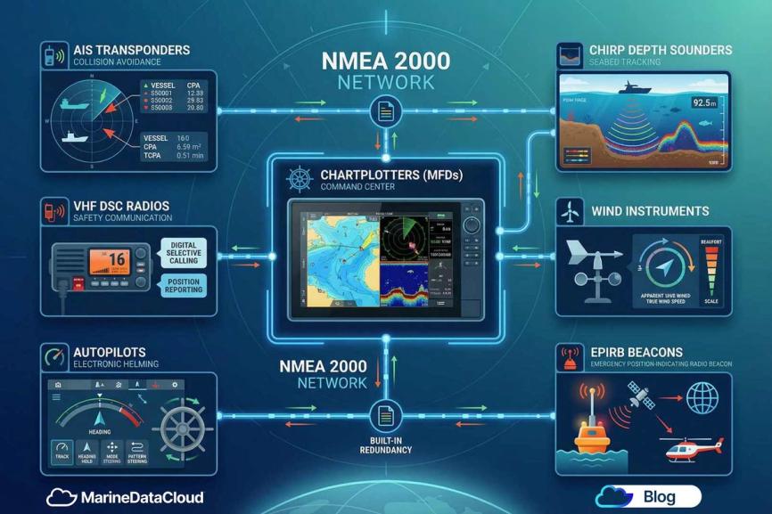
The chartplotter, or Multifunction Display (MFD), is the undisputed admiral of your navigation suite. Modern units from leading manufacturers such as Garmin, Raymarine, Simrad, and Furuno combine GPS positioning, electronic chart navigation, radar overlay, sonar imagery, and AIS tracking into a single, sunlight-readable touchscreen display. Screen sizes typically range from 7 to 24 inches for recreational vessels, with larger units offering split-screen capability that allows a skipper to monitor multiple data feeds simultaneously.
When selecting your MFD, prioritise chart compatibility — Navionics, C-MAP, and Jeppesen are the three dominant chart providers — alongside processing speed, screen brightness measured in nits (aim for at least 1,000 nits for daylight legibility), and the richness of your NMEA 2000 and Wi-Fi connectivity options. A modern MFD should serve as a hub, pulling in data from every sensor aboard and presenting it in a single, coherent display.
Eyes on the Water: AIS Transponders
Automatic Identification System (AIS) technology has arguably done more for collision avoidance than any other development in recent maritime history. Originally mandated under the SOLAS convention for commercial vessels over 300 gross tonnes, AIS has become near-universal across recreational sailing and power-boat fleets. A Class B AIS transponder — the standard for non-commercial vessels — transmits your vessel's MMSI number, name, position, course, and speed to all AIS-equipped vessels and shore stations within VHF range, typically 20 to 30 nautical miles.
The practical value is extraordinary. Approaching a busy harbour entrance in fog, or crossing a commercial shipping lane at night, your AIS gives both you and every other vessel around you a comprehensive, real-time traffic picture. Pair your AIS transponder directly with your MFD via NMEA 2000 and the targets appear directly on your chart overlay, complete with CPA (Closest Point of Approach) and TCPA (Time to Closest Point of Approach) calculations. For offshore passages, consider upgrading to a Class B+ (SOTDMA) transponder, which offers guaranteed transmission slots rather than the CSMA protocol of standard Class B units.
The Voice of Safety: VHF DSC Radios
No electronics suite is complete without a fixed-mount VHF radio with Digital Selective Calling (DSC) capability. VHF remains the universal distress and working frequency on the world's waterways, and DSC — operating on Channel 70 — allows a vessel in distress to transmit a digital alert containing its MMSI number and, crucially, its GPS position at the press of a single button. This is not a feature; it is a lifeline.
Connect your VHF DSC radio to your GPS source via NMEA 2000 or a direct NMEA 0183 connection, and ensure your MMSI number is registered with your national authority (in the UK, this is the MCA; in the US, the FCC). A correctly programmed and networked DSC radio transforms a routine radio call into a precision rescue-coordination tool, transmitting your exact coordinates directly to both the MRCC and any nearby vessels monitoring Channel 16.
Reading the Depths: Sounders and Sonar
A depth sounder is perhaps the most elemental of all marine instruments — and yet modern fishfinders and sonar units have evolved into extraordinarily sophisticated tools. Traditional single-frequency sounders have given way to CHIRP (Compressed High-Intensity Radiated Pulse) transducers, which sweep a range of frequencies simultaneously to produce dramatically cleaner bottom returns and superior target separation in the water column. Side-scanning and down-scanning sonar technologies, pioneered by Humminbird and Lowrance, produce near-photographic imagery of the seabed, invaluable for anchoring in unfamiliar waters or exploring coastal structure.
Mount your transducer carefully — ideally through-hull on the centreline, forward of the propeller wash — and connect it via NMEA 2000 to share depth, water temperature, and speed data across your entire electronics network.
Wind, Speed, and the Environmental Picture: Instrument Systems
A quality wind and environmental instrument system completes the sensory picture of your vessel's operating environment. Masthead wind transducers measure both True Wind Speed (TWS) and True Wind Angle (TWA), whilst paddlewheel or ultrasonic speed sensors through the hull provide Boat Speed (BSP) and Speed Over Ground (SOG) — the latter derived from GPS. Integrated with your MFD, these data streams feed your polar performance analysis, your waypoint ETA calculations, and your weather routing overlays.
Brands such as B&G — long the instrument of choice for offshore racing yachts — offer sophisticated instrument processors that calculate laylines, VMG (Velocity Made Good), and tacking angles in real time, transforming raw sensor data into tactical sailing intelligence.
The Electronic Helmsman: Autopilots
A modern marine autopilot is perhaps the most fatigue-reducing instrument aboard an offshore passage-maker. By holding a steady compass course or tracking a GPS waypoint, a well-tuned autopilot frees the crew for watchkeeping, sail trim, and navigation — the tasks that demand human judgement. Modern units employ adaptive algorithms that learn a vessel's helm characteristics over time, compensating automatically for wind shift, current, and sea state.
Autopilot systems consist of three key components: the course computer (the brain), the fluxgate or rate-gyro compass (the sensor), and the drive unit (the actuator — whether a linear actuator, hydraulic pump, or tiller drive). The quality and sizing of the drive unit to your vessel's displacement and rudder torque is critical; an under-powered drive is a false economy that will fail precisely when you need it most.
The Last Resort: EPIRB Beacons
An Emergency Position Indicating Radio Beacon (EPIRB) is the instrument you register, service, and hope never to activate. A Category 1 EPIRB, mounted in a hydrostatic release bracket, will automatically deploy and activate when immersed in water — transmitting a 406 MHz distress signal containing your unique vessel identifier and GPS position to the international COSPAS-SARSAT satellite network. Search and rescue authorities are typically alerted within minutes, with position accuracy to within 100 metres when an integrated GPS receiver is fitted.
SOLAS regulations mandate annual testing for commercial vessels, and whilst recreational boats are not always legally required to carry an EPIRB, any vessel venturing beyond coastal waters should treat one as absolutely non-negotiable safety equipment. Register your beacon with your national authority — in the UK with the MCA Beacon Registry — and update the registration whenever vessel details or contact information changes.
The Nervous System: NMEA 2000 Networking
All of the instruments described above are significantly more valuable connected together than they are operating in isolation. NMEA 2000 (N2K) is the international standard communication protocol — based on the CAN (Controller Area Network) bus architecture — that forms the nervous system of a modern marine electronics installation. Standardised by the National Marine Electronics Association, NMEA 2000 allows devices from multiple manufacturers to share data on a single network backbone.
The physical network consists of a backbone cable — typically a 5-wire shielded trunk — with T-connectors, drop cables, and terminating resistors at each end. Every device on the network, called a node, communicates via standardised PGNs (Parameter Group Numbers), which define the data format for everything from GPS position and depth to engine RPM and battery voltage. A single N2K backbone can support up to 50 nodes, providing a remarkably scalable platform for a growing electronics suite.
The practical result is elegant: your MFD displays depth data from your sonar, wind data from your masthead transducer, AIS targets from your transponder, and engine data from your NMEA 2000-compatible engine — all on a single screen, all from a single network connection. Integration of this kind was once the preserve of superyachts; today it is accessible to any vessel with a thoughtfully planned wiring harness.
Redundancy: The Mark of a Properly Equipped Nav Station
The final — and perhaps most important — principle of a professional electronics installation is redundancy. The sea is an unforgiving environment for electronics; salt air, vibration, moisture ingress, and electrical surges can disable any single device without warning. A properly equipped nav station plans for failure from the outset.
Practical redundancy means: a backup chartplotter — even a waterproofed tablet running Navionics or iNavX with a separate GPS puck — independent of your primary MFD circuit; a handheld VHF radio with its own charged battery, stored separately from the fixed unit; a separate GPS receiver that can feed your autopilot independently of your chartplotter; and a dedicated compass — fluxgate or traditional magnetic — that requires no electrical power whatsoever. Paper charts covering your intended cruising area remain, unarguably, the ultimate backup navigation tool.
Power redundancy matters equally. Ensure your navigation electronics are split across at least two separate fused circuits fed from independent battery banks. A catastrophic electrical fault that disables one bank must not simultaneously silence every instrument aboard.
Summary: Key Takeaways for the Modern Digital Navigator
- The chartplotter (MFD) is your nav suite's command centre — choose one with superior chart compatibility, high screen brightness, and rich NMEA 2000 connectivity.
- AIS transponders provide real-time collision avoidance intelligence; connect them directly to your MFD for integrated chart overlay and CPA calculations.
- VHF DSC radios are a legal and moral necessity — register your MMSI, connect to GPS, and ensure Channel 70 DSC is always active.
- CHIRP depth sounders deliver superior bottom-tracking accuracy; mount the transducer correctly for clean, reliable depth data.
- Wind and speed instruments feed your tactical picture — from basic SOG to sophisticated VMG calculations for performance sailing.
- Autopilots size correctly to your vessel's displacement and rudder torque — a properly tuned autopilot is your most tireless crew member on passage.
- EPIRB beacons save lives — register yours, test it annually, and fit a Category 1 unit in a hydrostatic release bracket for any offshore work.
- NMEA 2000 networking is the backbone that unites all devices into a single, coherent, data-sharing system — plan your backbone before you buy a single instrument.
- Redundancy is not optional — a second GPS source, a handheld VHF, paper charts, and split electrical circuits are the marks of a vessel ready for whatever the sea presents.
Digital competence, properly built and intelligently maintained, is seamanship. Navigate accordingly.